-
Details
- Alternative title
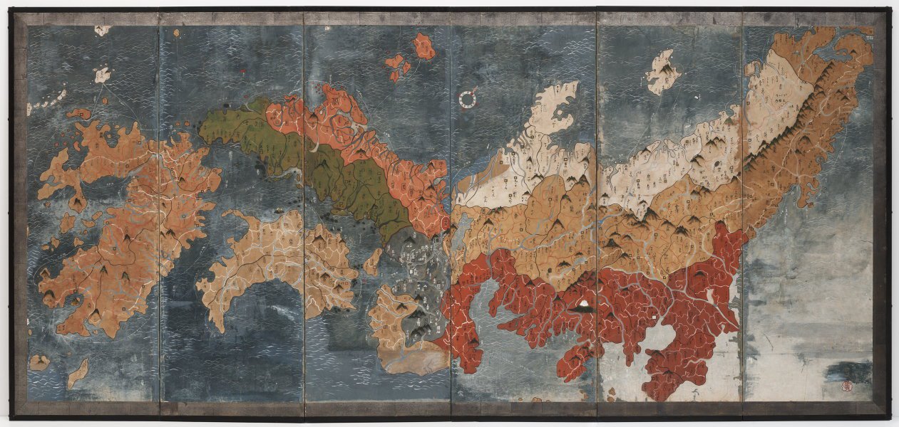
- Map of Japan with the five provinces and seven circuits
- Place where the work was made
-
Japan
- Cultural origin
- Japan
- Period
- Edo (Tokugawa) period 1615 - 1868 → Japan
- Date
- circa 1830
- Media category
- Painting
- Materials used
- single six-panel screen; pigments and silver leaf on paper
- Dimensions
- 168.0 x 352.0 cm
- Signature & date
Seal of Sugae Ryo 菅江嶺
- Credit
- Purchased with funds provided by the Asian Art Collection Benefactors 2021
- Location
- Not on display
- Accession number
- 44.2021
- Copyright
- Artist information
-
attributed to Sugae Ryo
Works in the collection
- Share
-
-
About
Made around 1830, this folding screen shows Japan as it was viewed at a time when the country was still actively isolated from the rest of the world. Although not common, map screens are known to have been produced in Edo period (1603–1868) Japan. This example records the entire country with what were known as the ‘Five provinces’ and ‘Seven Circuits’ of the nation colour coded. The map also depicts towns, castles, mountains and rivers, nearby islands and sea trade routes.
Clearly visible in the centre lower right is a snow-capped Mount Fuji. Other landmarks include the whirlpools of Naruto between Shikoku and Awaji island, the Izumo Shrine marked by a Torii gate and Osaka Castle indicated by a white square. The map reflects the time in which it was created. For instance, Hokkaido and Okinawa were not then considered part of Japan and do not appear. Also absent are the now major cities of Yokohama and Kobe which at the time were just small villages. Kyoto, the national capital before it moved to Edo (now Tokyo), appears as a large double square surrounding the character word Kyo (京), meaning capital.
The painting follows an established map-drawing style known as Gyōkizu after the monk Gyōki who is believed to have created numerous maps during the Nara period (710–84). This style informed Japanese maps in all media – from screens to ceramics – until 1821 when Ino Tadataka (1745–1818) published his first Ino-zu maps using European cartographical approaches. Map screens produced in the 16th century are classified as Important Cultural Property and held in temple and museum collections in Japan. The proposed date of around 1830 for this screen suggests it may have been one of the last to which the Gyokizu approach was applied.
The detailed depiction of commercial sea trade routes suggests the screen may have been commissioned by a feudal lord with trade interests. The painter’s seal on the screen is that of Sugae Ryo (1762–1852) from Hagi near the Japan Sea. He is known to have served for eight years as court painter to Mori Narimoto 11th Lord of Choshu Fief (lived 1794–1836, daimyo of Choshu 1824–36). The sea compass in the upper centre of the screen is marked by feng shui (geomantic) zodiac characters; for instance, there is a dragon to indicate north.
A fascinating aspect of the screen is that labelling appears in at least two hands, one more literate than the other, and there are mistakes throughout. Many of the names of places are transcribed as they would have sounded at the time rather than how they were written, often changing the meaning.
-
Places
Where the work was made
Japan
-
Exhibition history
Shown in 1 exhibition
Elemental, Art Gallery of New South Wales, Sydney, 30 Jul 2022–2024
-
Bibliography
Referenced in 1 publication
-
Melanie Eastburn, Look, 'Elemental', pp. 34-41, Sydney, Aug 2022-Sep 2022, 38-39 (colour illus.).
-
-
Provenance
Chiiori Ltd, 2015-Apr 2021, Kyoto/Japan, purchased at auction in Kyoto, 2015. Purchased by the Art Gallery of New South Wales, Sydney, April 2021.
